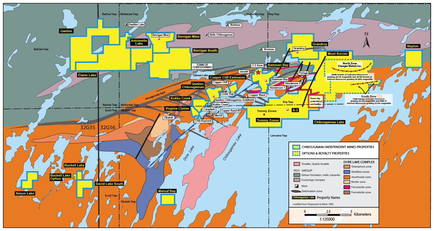

Properties
Baie Malouf
Bateman Bay
Berrigan Mine
Berrigan South
Buckell Lake
Copper Cliff Extension
Grandroy
Gwillim
Kokko Creek
Lac Antoinette
Lac Chibougamau
Lac David
Lac Élaine
Lac Simon
Mont Sorcier
Nepton
Quebec Chibougamau GoldFields
Virginia Option
|
 |
Chibougamau Mining Camp - Au, Cu, Ag, Zn, Fe
Lemoine, McKenzie, Obalski, Roy, Scott & McCorkill Townships, Quebec
(NTS 32G/15-16)
An Overview
Project Description and Location
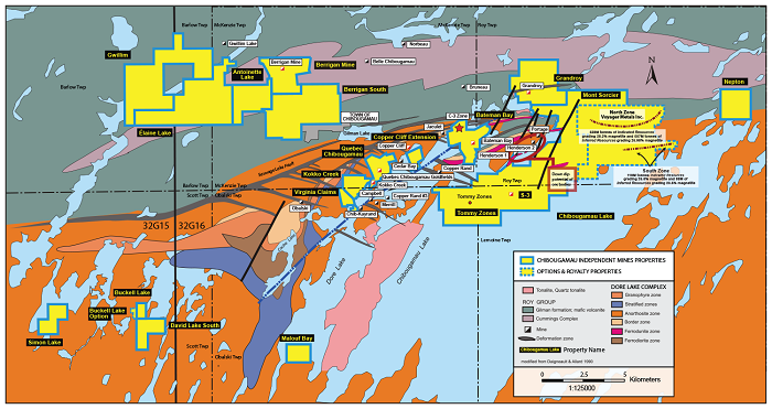
Under a plan of arrangement dated September 10, 2012 all the Chibougamau mining properties were transferred to Chibougamau Independent Mines Inc. effective December 29, 2012. It will be recalled these properties consist of distinct project sites located within the Abitibi in the Chibougamau Mining District and encompasses portions of Lemoine, McKenzie, Obalski, Roy, Barlow, McCorkill and Scott Townships (NTS 32G/16). As of March 2017, the aggregate of registered units (claims/cells) held wholly by Chibougamau Independent Mines (CBG) totalled 259 units and 11, 131 hectares with individual projects including Berrigan Mine (16 cls), Berrigan South (23 cls), Lac Antoinette (11 cls), Lac Élaine (27 cls), Virginia Option (4 cls), Kokko Creek (7 cls), Quebec Chibougamau GoldFields (7 cls), Copper Cliff Ext. (7 cls), Bateman Bay (15 cls), Grandroy (15 cls), Mont Sorcier (37 cls: formerly Sulphur Converting/ Magnetite Bay ), Buckell Lake (Royalty Property - 2 cls), Lac Chibougamau (72 cls), Baie Malouf (2 cls), Nepton (6 cls), Lac Simon (3 cls) and Lac David Sud (4 cls). It will also be recalled the 2012 land holdings were expanded in 2013 by way of additional staking. The majority of the properties are located 15 kilometers E-SE from the town of Chibougamau (population >5,000) with some claim groups extending south and east along the west shore of Lake Dore while a larger segment extends approximately 4km South, East and Northeast of the Henderson Number 1 shaft, over Lake Chibougamau. The Berrigan claim group extends 12km W and NW from the town of Chibougamau. All of the undermentioned properties are subject to a 3% gross metal royalty in favour of Globex.
This large land position is considered to be at an “advanced stage” of exploration, being located for the most part on the inferred lateral and depth extensions of the better copper-gold producers of the mining camp as well entirely encompassing several of camp’s former copper/gold producers.
All mandatory work permits issued by the Provincial Ministry of Natural Resources (MNRF) for land based drilling and the Ministry of the Environment (MDDEP) for ice drilling on lakes, were applied for and obtained by CBG for the completed 2013 work program.
* Properties included in the Chibougamau Mining Camp are:
Accessibility, Climate Local Resources, Infrastructure and Physiography
Chibougamau is an active mining and forestry centre (pop. >5,000 persons) located on Highway 113 which connects with the large mining community of Val d’Or (pop.> 40,000 persons) 400km to the SW and the agricultural centre of Lac St. Jean 250km to the SE. The area enjoys good infrastructure with railway, hydro power and a good mining work force because of its 60 years of mining activity in the Chibougamau/Chapais district. A dormant but still operative 3,000 tpd mill is available for custom milling. Chibougamau is serviced by regular commercial flights to Montreal, Quebec and serves as the gateway for other mining/forestry activities for the more northern regions of the Province. Climate conditions are typical of the Canadian Shield, averaging -30 degrees Celsius in January/February and an average of + 25 degrees Celsius in July. The ground is generally snow governed from November to March and summers are relatively hot and relatively wet. Topography is generally flat except for local 200-500m high knobby E-W trending hill tops. Many of the mineral claims are underlain by the Chibougamau and Dore lakes. The CBG properties are generally moderately to locally densely forest in black spruce, birch, aspen and tag alders where ground conditions are swampy.
History
Since the onset of land acquisition in 2007 by Globex Mining Enterprises, ongoing acquisition by ground staking and/or map designated cells by the latter has resulted in the acquisition of a significant land package in the Chibougamau Mining Camp. Under an Agreement, dated September 10, 2012, between Globex and CBG, the aforementioned properties, were transferred 100% to CBG effective December 29, 2012. The properties are subject to a 3% gross metal royalty in favor of Globex.
Copper and gold were discovered in the early 1900’s and roads and railroad access were completed in the early 1950’s. The town of Chibougamau was established in 1952 and numerous mines were developed along the shores of Lac Doré and Lac Chibougamau. Numerous change of ownerships occurred between 1955 and 2012. The initial miner in the Camp, Campbell Chibougamau Mines became Copper Rand Chibougamau Mines Ltd, which subsequently became Patino Mines Ltd in 1962. In 1981, Northgate Exploration Ltd acquired Patino Mines Ltd. In 1987, Northgate sold its assets to Westerminer (Canada) Ltd. which subsequently sold all of these assets to Resources MSV Inc. in 1993. In 2001, Res. MSV and Geonova Explorations Inc amalgamated to create Resources Campbell which went bankrupt in 2010. In 2012, Nuinsco Resources and Ocean Partners acquired the remaining assets of Resources Campbell Inc, creating a new exploration and development company, C-Bay Resources, now active in the Camp.
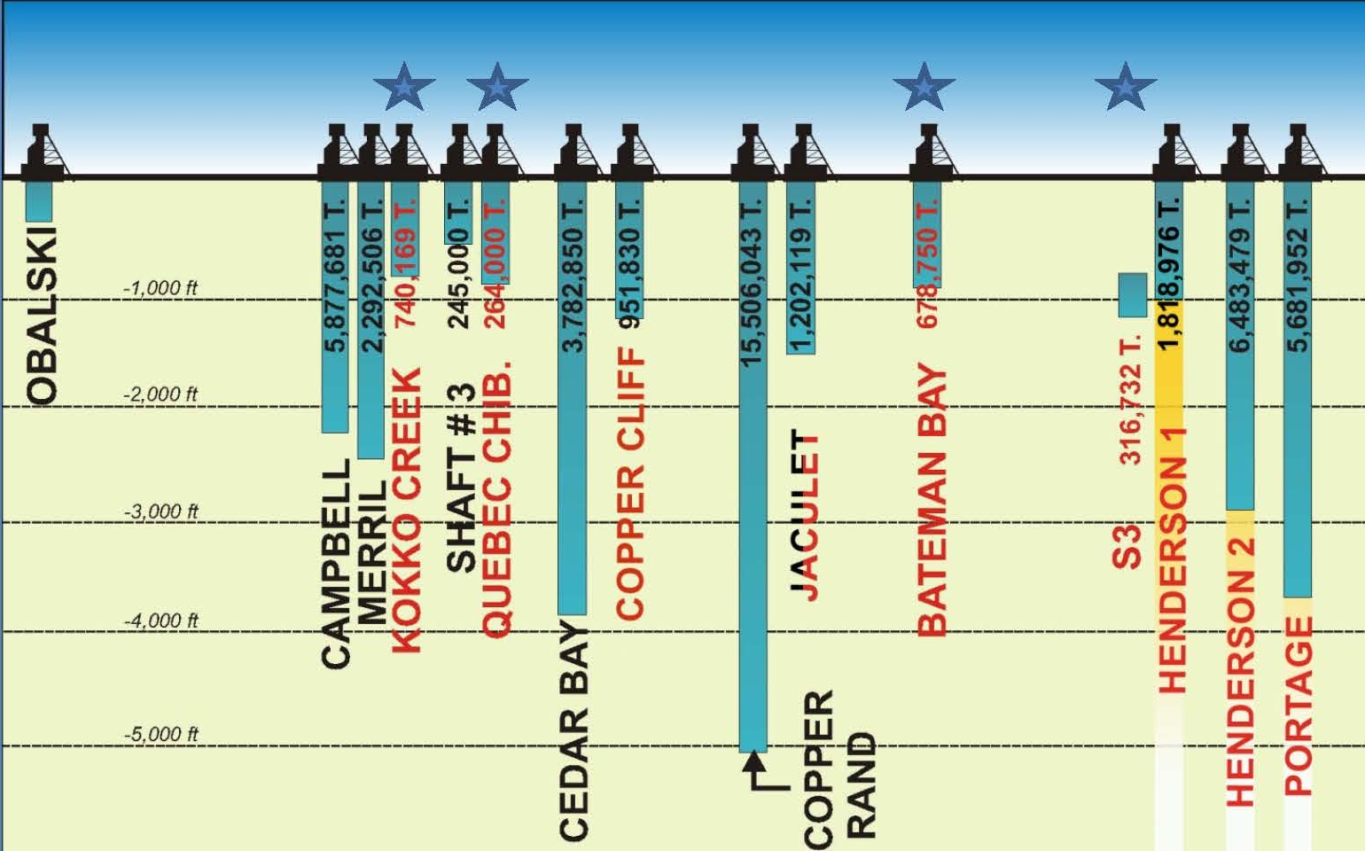
The simplified longitudinal section below (Figure below) gives general production numbers and maximum vertical depth of investigation for the majority of the deposits in the camp with four of the five past Cu/Au producers currently held by CBG identified with a star symbol.

Except for regional geological mapping and airborne surveys carried out by different levels of government, all of the historic available information on the CBG claims originated from the Campbell/Camchib exploration work. This information was compiled and interpreted by SOQUEM. They carried out extensive compilation of geologic, geochemical and geophysical survey data, but limited surface exploration work (geophysics and drilling) during the period 1992 to 2000. Although a number of the SOQUEM drill holes located new copper/gold mineralization, no additional work followed this initial success.
Various airborne geophysical surveys have confirmed the presence of a number of magnetic and electromagnetic anomalies in the area of known mineralized zones and/or along their inferred strike direction. These surveys have helped in the interpretation of the regional geology and general stratigraphic relationships of the volcanic and large intrusive complexes in the Camp. Numerous geophysical anomalies remain yet to be tested by drilling.
Geological Setting
Regional Setting
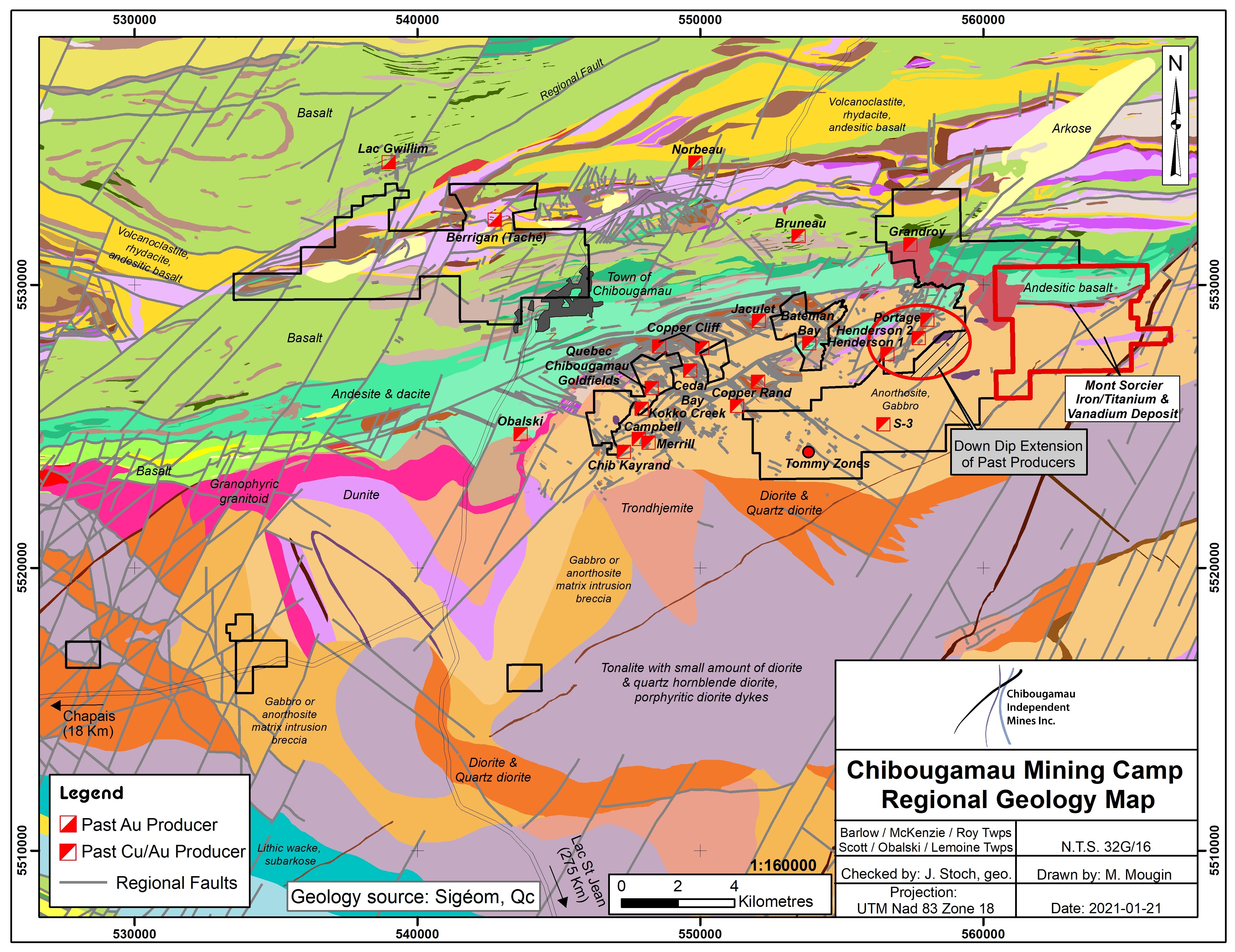
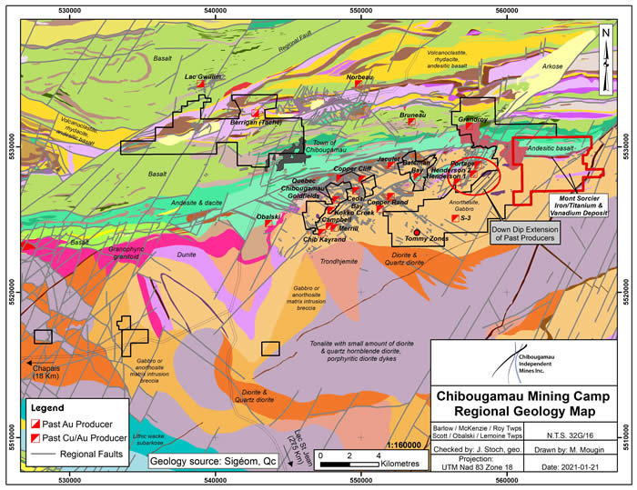
The Archean rock formations which underlie the Chibougamau Mining Camp form the eastern portion of the Chibougamau-Mattagami segment of the Abitibi Greenstone Belt. The volcanic rocks and associated sediments belong to the Roy Group which is subdivided into the Blondeau, Bruneau, Allard, David and the Obatagamau Formations with the latter being the oldest underlying unit. The Cummings Group mafic intrusive rocks have intruded predominantly at the contact between the Bruneau and the Blondeau volcanic formations. The volcanic formations have been folded about a large regional fold into which the Lac Dore Complex and later the Lac Chibougamau tonalite-trondhjemite Pluton have been intruded. Regional metamorphism is green schist facies. The Opemisca sediments unconformably overlie the aforementioned volcanic units. The Lac Dore Complex (LDC) is a stratiform, layered intrusive complex composed principally of meta-anorthosite with lesser amount of meta-gabbro to anorthositic gabbro and is host to many of the copper/gold deposits of the Camp. The anorthosite represents 70% to 90% (by volume) of the lithologies present within the LDC.
The past producing copper/gold deposits within and adjacent to the CBG properties are generally located within the layered segment of the Lac Dore complex. The “anorthositic” facies of the complex shows evidence of intruding into the older “layered” sequence, thus locally creating large “rafts” of layered peridotite to anorthositic gabbro within the more abundant anorthosite mass. The primitive magmatic layering is often composed (from base to top) of ferro-dunite, ferro-peridotite, ferro-pyroxenite, ferro-gabbro and intern layers of magnetite bearing gabbroic anorthosite. Layered iron-titanium-vanadium mineralization such as at the Mont Sorcier property is also recognized in this environment.
The Lac Dore Fault (LDF) is the most prominent structure in the area. It trends roughly NE, dips 70 degrees to the NW and may have a “thrust” component in its movement. This fault transects and locally displaces numerous of the former producers, which attests, at least in part, to post mineral movement along this fault structure.
Further NW away from the LDC, in the area of CBG’s Berrigan and Berrigan South properties, another series of differentiated mafic to ultramafic sills referred to as the Cummings Complex, are injected predominantly along the contact zones between the Gilman and Blondeau volcanic formations. Zinc/copper/gold/silver mineralization are found at numerous locations within and on the margins of these sills while various occurrences of volcanogenic stringer and massive sulphide (VMS) mineralization (Cu/Zn/Au/Ag) are reported to be present in the aforementioned volcanic sequences.
The central highly sodic Chibougamau Pluton cores the LDC and shows an intrusive contact with the Anorthositic Zone of the LDC on the north flank of the regional anticline. Principal rock types within the Pluton include granodiorite, quartz syenite, hornblende tonalite and hornblende melano-tonalite. Satellite intrusions such as the Grandroy stock and Line Lake Stock may display porphyry style Cu/Au mineralization.
The Chapais-Chibougamau Mining District was subjected to superposed regional deformational events during the Archean which resulted in large scale isoclinal folding and related faulting of the extrusive, intrusive and sedimentary rock units. Five major fracture/shearing systems are recognized. One such set of faults includes the major NE trending, NW dipping regional Gwillim, Lac Dore, McKenzie Narrows and Lac Tache faults, with dextral strike-slip displacement. The Lac Doré structure is metallogenically important because of its displacement of the SE trending “Mine shears” associated with the mined Cu/Au mineralization as occurs at Copper Rand, Copper Cliff, Jaculet, Bateman Bay and Kokko Creek. Elsewhere, N-S structures are well developed in the volcanics and Cummings Complex and show a close association with some of the important orogenic gold deposits in the Camp.
Local Setting
The local geological setting is addressed on a property by property basis in the following sections of this segment of the report. The Chibougamau Camp scale, land holding can be categorized into three main geologic groups.
Group 1: These holdings are located within the layered portion of the Lac Doré mafic to ultramafic Intrusive Complex (LDC) positioned between the volcanic formations of the David Group to the NW and the central tonalite-trondhjemite Chibougamau Pluton to the SE. The majority of the Cu-Au mines in the Camp are found within the layered portion of the Lac Doré Complex. This claim group includes the following deposits and mineralized occurrences: Bateman Bay(Au, Cu) & Jaculet Extension, Copper Cliff Extension (Au, Cu), Kokko Creek (Au, Cu), Quebec Chibougamau Mines (Au, Ag, Zn), “S” Zones(Au, Cu) and “T” Tommy/Yorcan Zones (Au, Cu).
Group 2: These holdings straddle the contact between the layered zones of the LDC to the south in contact with the mafic/felsic volcanics to the north. The Grandroy Mine intrusive stock, a satellite body to the Chibougamau Pluton, also straddles this contact. This claim group includes the following deposits and mineralized occurrences: Grandroy Mine (Cu, Au, Mo), Ile Marguerite (Au), Mont Sorcier (Fe-Ti-V) and Sulphur Converting (Cu-Zn).
Group 3: These holdings are located NW of the latter within the mafic to felsic volcanics of the Bruneau and Blondeau Formations intruded by the differentiated mafic/ultramafic Cummings Complex. This group includes the Berrigan Lake Mine (Au, Ag, Zn) and the Berrigan South prospect (Zn, Au).
Mineralization
The prominent anorthosite facies of the LDC shows numerous “tectonic corridors” serving as conduits for the mineral bearing hydrothermal solutions which streamed through the rock formations resulting in characteristic “wallrock” alteration features and assemblages including typical sericite, chlorite, carbonate and quartz directly associated with the sulphide minerals within these tectonic corridors in which develop mineralized lenses of various dimensions. Mineralization within the “tectonic corridors” generally consists of lenses of 10%-30% sulfides comprised largely of pyrite, chalcopyrite with some pyrrhotite (5% to 15%) along with minor sphalerite and galena. The matrix of the mined lenses is composed of 70%-90% chlorite with lesser quartz and carbonate, which can account for 15% to 20% of the matrix.
The Cu-Au mines may, at certain locations, display concentrations of semi-massive to massive sulphides (pyrite, pyrrhotite, and chalcopyrite) commonly at the contact of felsic to intermediate dykes intruded within larger zones of deformation characterized by chlorite-sericite quartz-carbonate schists, affecting the anorthosite of the Lac Doré Complex. These shear zones, often referred to as the “mine shears”, are usually oriented at 110°. However, a large part of the production in Chibougamau came from an earlier N45°E shear structures. These structures show great depth extensions and have been cut and displaced by the Lac Doré Fault, showing an apparent horizontal sinistral displacement of approximately 1.6 km. This regional structure (Lac Doré Fault) trends northeast and dips 50° to 70° to the north-west. The “mine shears” dip SW and the main N-045° shear, dips SE.
The CBG properties include a) the unmined zinc/gold Berrigan Project (NI 43-101 compliant report by C. Larouche, May 17,2011, restated August15, 2012), b) the unmined zinc/gold Berrigan South deposit, c) five past producing copper/gold deposits (including Kokko Creek, Quebec Chibougamau Goldfields, Bateman Bay, S-3 Zone and Grandroy Gold & Copper Mine, d) the inferred lateral and depth extensions of the largest past producing mines in the Camp (Portage/Henderson Mines), e) the Ile Marguerite (talc zone) and large Mont Sorcier (Fe-Ti-V) deposit as well as a number of other gold/copper zones including the Tommy (T Zones), and K Zones. The north portion of the claim group straddles the contact between the layered zone of the Lac Dore Complex to the south in contact with mafic + felsic volcanic rocks to the north where the “porphyry type exploration model appears to offer attractive discovery potential as exemplified by the Grandroy porphyry Cu/Au deposit.
The following “historical” non NI 43-101 compliant resources have been published on the CBG properties. A qualified person has not performed sufficient work to classify the historical estimates as current mineral resources or mineral reserves and CBG is not treating the historical estimates as current mineral resources or mineral reserves.
| Name of project |
Historical Resources |
Cu % |
Au g/t |
Zn % |
| Bateman Bay |
396,665 tons |
2.64 % |
4.35 g/t |
|
| Berrigan Mine (North Zone) |
1,388,915 tons |
|
1.77 g/t |
3.17 % |
| Berrigan Mine (South Zone) |
259,637 tons |
|
0.58 g/t |
3.05 % |
| Grandroy Mine |
181,000 tons |
1.50 % |
|
|
| Kokko Creek |
115,000 tons |
1.50 % |
0.21 g/t |
|
| Quebec Chibougamau |
19,191 tons |
1.93 % |
2.64 g/t |
|
| T-Zones (T-10) |
449,095 tons |
0.91 % |
2.38 g/t |
|
| T-Zones (T-9) |
50,000 tons |
2.21 % |
|
|
| T-Zones (T-8) |
440,000 tons |
|
8.48 g/t |
|
Exploration
In 2011, consulting geological engineer Claude Larouche, ing. (O.I.Q.) commenced, under the direction of Globex Mining initially and subsequently for Chibougamau Independent Mines (CBG), a comprehensive compilation of the published and assessment file geologic, geochemical, geophysical and mining data relative to CBG‘s land holdings. The objective of this study was to provide a functional database to guide and plan systematic exploration to locate and drill test new mineral deposits in the vicinity of past producing and unmined primarily copper–gold or zinc–gold rich deposits in the Camp.
In 2012, the aforementioned study resulted in the completion of two NI 43-101 compliant technical reports by Claude Larouche including respectively the Evaluation and Exploration Potential of the Berrigan Gold/Zinc/Silver Project, McKenzie Twp (initially dated May 17, 2011 & restated August 15, 2012) and the Exploration Potential of the Lac Chibougamau Mining Properties (initially dated August 16, 2012 and restated December 17, 2012). Both of these reports were filed on www.sedar.com in 2012. In these reports, consultant Claude Larouche details a proposed multi-phase work program including respectively an initial Phase I budgeted at $605,000 for Berrigan and $1.15M for the Lac Chibougamau Properties for data compilation and exploration drilling and a Phase II program consisting respectively of diamond drilling budgeted at $2.09M for Berrigan and $2.97M for Lac Chibougamau Properties to confirm and upgrade historic copper and gold resources into a NI 43-101 compliant category.
Field work in 2012 involved the completion of 22 ln-km of a newly designed, deep penetrating geophysical I.P. survey along with 44.5 ln-km of conventional complimentary magnetometer coverage and 19.9 ln-km of horizontal loop electromagnetic surveys (HEM) over selective portions of the S2/S3 copper/gold zones over Lac Chibougamau. An unusually early spring break up precluded the completion of the larger survey area on the ice of Lac Chibougamau. The partial results of this orientation work did; however, prove successful in generating clear geophysical responds over the known zones of mineralization while indicating the potential for vertical & lateral extensions of the mineralized structures. This field work was carried out during the winter months of February and March 2012.
Exploration and Development
In the first Quarter of 2013, the deep penetrating IP survey work on the ice of Lac Chibougamau was continued from the previous year. An aggregate of 40.6 km of dipole-dipole & deep IP along with accompanying ground magnetometer and HEM electromagnetic surveying was completed over the Tommy Zones, the Bateman Bay Zone, the Grandroy South Zone and Kokko Creek from early February to the end of March 2013. The interpretation of the results from these various grid areas is expected in the early part of the second Quarter of 2013.
An eight hole diamond drill program totaling 1,809 metres was also completed on the Berrigan Zn/Au/Ag deposit from February 1 to 15, 2013. The program was designed to directly confirm information on the style and grade of mineralization to guide a subsequent, more comprehensive, drill program to enable a NI 43-101 compliant resource calculation of this deposit. While assay results are pending at the time of this report, visual inspection of the sulphide (sphalerite) mineralization in drill core tentatively suggests a generally good fit (position & grade) between historic zinc intercepts and those generated from the 2013 drill program. Gold and silver content confirmation will however be very dependent on the forthcoming laboratory assay results.
|